Mt. Kedar Dome
- Home
- Mt. Kedar Dome
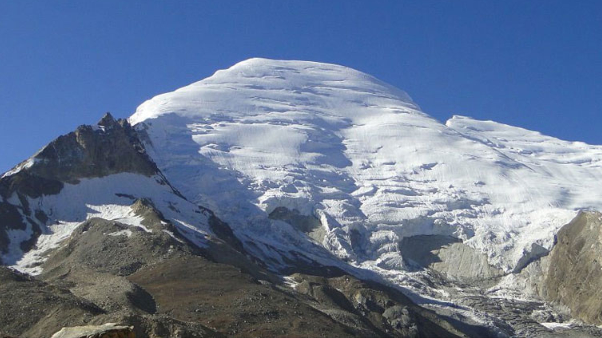
Mt. Kedar Dome (Max Altitude 6832 m)
A challenging yet exhilarating ascent—an advanced expedition designed for seasoned climbers.
Mt. Kedar Dome
Grade 7+Description
Situated in the Garhwal region of the Himalayas and surrounded by iconic summits like the Bhagirathi massif, Shivling, Satopanth, and the Gangotri peaks, Mt. Kedar Dome rises to an impressive 6,832 meters. True to its name, this elegant mountain features a dome-shaped crest and sits about 2 km northeast of the spiritually important Kedarnath Peak, bringing climbers remarkably close to the 7,000-meter mark.
The expedition begins in the sacred town of Gangotri and takes you through an enchanting blend of terrain—starting with the dense green stretches of Chirbasa, leading into the vast alpine meadows of Tapovan, and then progressing onto the icy expanse of the Kirti Glacier before the climb up the mountain’s frozen slopes begins. Our ascent follows the standard northeastern route, known for being more manageable than the significantly harsher eastern face. Though the altitude adds both excitement and difficulty, this peak is ideal for those seeking a high-altitude adventure with comparatively fewer technical demands.
Despite being only moderately technical, scaling Kedar Dome involves long traverses over rocky moraines, negotiating the formidable Kirti Glacier, crossing snowfields riddled with crevasses, and making a strenuous push to the summit through thinning air and strong, persistent winds. Because of the height and terrain, climbers must be familiar with mountaineering gear and possess the necessary skills to operate safely in such extreme conditions. For this reason, the expedition is recommended solely for seasoned climbers. Participants must either hold mountaineering certification or have substantial experience in high-altitude climbing and harsh weather environments. The most favorable months for attempting Kedar Dome are June and September.
Continue exploring this page for complete details on the Mt. Kedar Dome expedition—its itinerary, climbing routes, FAQs, and eligibility requirements.
Brief Itinerary
Day 1: Make your way to Gangotri (3,415M)
Day 2: Rest and acclimatization at Gangotri (3,415M)
Day 3: Gangotri (3,415M) to Bhojwasa (3,775M) via Chirbasa (3,600M)
Day 4: Bhojwasa (3,775M) to Tapovan (4,460M) via Gomukh (4,025M)
Day 5: Tapovan (4,460M) to Kirti Glacier/ Base Camp (4,740M)
Day 6: Acclimatization at Base Camp
Day 7 – Day 17: Expedition
Day 18: Depart from Gangotri
Day 19 and 20: Reserve Days
Detailed Itinerary
Day 1: Arrival at Gangotri (3,415 m)
Long drive from Dehradun (~245 km, 8–9 hours)
Early assembly at 7 AM to account for mountain road delays
Check-in and settle in at Gangotri
Day 2: Rest & Acclimatization at Gangotri (3,415 m)
Explore local markets and high-mountain culture
Debriefing: trek schedule, dos & don’ts, environmental guidelines
Short evening acclimatization walk
Day 3: Gangotri → Bhojwasa (3,775 m) via Chirbasa (3,600 m)
Distance: 14 km Trek
Trek alongside Bhagirathi River to Chirbasa (“home of pine”)
Continue to Bhojwasa (“home of birch trees”)
Evening: sunset views of the Bhagirathi range; overnight by the river
Day 4: Bhojwasa → Tapovan (4,460 m) via Gomukh (4,025 m)
Distance: 13 km Trek
Cross Gomukh glacier snout (source of Ganga)
Trek over moraine-rich glaciers to Tapovan alpine meadows
Stunning views of Shivling, Bhagirathi I–III, wild Bharal herds
Overnight at Tapovan
Day 5: Tapovan → Kirti Glacier / Base Camp (4,740 m)
Distance: 9 km Trek
Trek along the base of Shivling Peak to Kirti Glacier
Terrain: boulders and glacier with hidden crevasses; exercise caution
Views of Kedardome, Kedarnath, Bhartekuntha, Thalay Sagar, Bhrigupanth, Meru, Bhagirathi, Shivling
Day 6: Acclimatization at Base Camp (4,740 m)
Rest and acclimatization for altitude (gain ~1,325 m from Gangotri)
Gear distribution and technical training on icy slopes
Day 7–Day 17: Expedition
Camps: Base Camp → Advanced Base Camp → Camp 1 → Summit Camp
Rotation rounds for acclimatization: “Climb High, Sleep Low”
Load ferry to higher camps, leaving supplies and returning to lower camps
Terrain: glacial moraine, boulders, snowfields, hidden crevasses
Summit Attempt (Days 13–14):
Summit Camp → Kedar Dome summit (~6,831 m)
Early start (12–1 AM) for 8–10 hours ascent
Alternating snow and rock slopes; last 150 m involves technical rock climbing
Descent: Summit → Summit Camp → ABC → Base Camp
Day 14–16: Gradual descent back to Bhojwasa
Day 18: Depart from Gangotri
Summit celebration and departure
Option to stay extra days to account for unforeseen delays
Day 19–20: Reserve Days
Reserved for bad weather or other unexpected conditions preventing summit attempts
Other Treks
What's Included
- Food as per menu on the trek
- Forest Permits/Camping Charges (upto the amount charged for Indian nationals)
- 4 season Dome Tents, Thermal rated Sleeping bags, Sleeping mats
- Safety Equipment includes static rescue rope, seat harness, carabiners, pulleys
- Expedition guide, cook, helpers, HAP and LAP for carrying common supplies
- Course certified & experienced Expedition Leader with Wilderness Emergency Responder & Rescue. course from NIM Uttarkashi
- Technical Equipment – PP Ropes, Helmet, Ice Axe, Crampons, Mountaineering Boots, Snow Stake, Dead Man/Boy
- Peak Booking Fee Charges (upto the amount charged for Indian nationals)
What's Not Included
- Portage of personal bags during the expedition
- Meals during road journeys from Dehradun to Gangotri
- Meals during hotel stay in Gangotri
- Cost of any kind of Travel Insurance.
- IMF fee only for foreign nationals US$ 700 for a team of two members and US$ 325 for every additional participants
- Forest Permit / Camping Fee for foreign nationals (USD 880-1000 upto group of 10)
- Mandatory Liaison Officer Fee for foreign expeditions ( ~USD 500 for group of 10)
Frequently Asked Questions
Mt. Kedar Dome sits in the Garhwal Himalayas of Uttarakhand, close to prominent peaks like Shivling, Satopanth, Bhagirathi, and Kedarnath Dome. The expedition begins from the holy town of Gangotri.
The peak stands at an elevation of 6,832 meters, placing it just below the coveted 7,000-meter mark.
Kedar Dome is considered moderately technical. Although the route is less demanding than nearby 7,000-meter peaks, climbers will still face glacier travel, moraines, crevasses, and steep snow or ice slopes. It is suitable only for experienced mountaineers.
This climb is recommended for seasoned climbers who have prior high-altitude experience and familiarity with mountaineering equipment. Certification in mountaineering or equivalent experience is essential.
Participants must be able to:
Use crampons and an ice axe
Move safely on glaciers
Manage roped travel
Handle extreme cold and high-altitude conditions
Previous experience above 5,000–6,000 m is strongly preferred. for more info Kailasa Treks.